Book review: Historical Maps and Classical Thoughts of Human Settlements in Chinese Cities
by Wang Shusheng and reviewed by Clifford Pearson
- Created
- 30 Jun 2020, 12:01 p.m.
- Author
- Clifford Pearson
- DOI
- 10.1177/0042098020927998
Book review: Historical Maps and Classical Thoughts of Human Settlements in Chinese Cities
by Wang Shusheng and reviewed by Clifford Pearson
Historical Maps and Classical Thoughts of Human Settlements in Chinese Cities (18 volumes), Beijing: Science Press Ltd., Longmen Book Company, 2015; 6615 pp.: RMB ¥9850 (hbk)
Hundreds of millions of Chinese have moved from the countryside to cities during the past 30 years, transforming the nation’s metropolitan areas in radical and lasting ways. If Mao Zedong were somehow to return and visit today’s Chinese cities, he would have a hard time finding his way around. Most of the hutong neighbourhoods in central Beijing have been wiped away or altered beyond recognition. Entire new districts with very tall office towers and sprawling residential complexes, such as Pudong in Shanghai, have sprouted from rice fields and agricultural land. Places that had been mere villages when the Chairman died in 1976 are giant cities like Shenzhen with millions of residents. So it is not surprising that most scholars of urban planning have focused on all that is new about Chinese cities. What is surprising is that one scholar, Wang Shusheng, would dedicate 12 years of his time to leading a comprehensive effort to research and analyse the historical record of more than 1400 ancient Chinese towns and cities.
The result of Wang’s efforts is Historical Maps and Classical Thoughts of Human Settlements in Chinese Cities, an impressive 18-volume atlas (see Figure 1 and Appendix) of traditional urban planning that spans 6615 pages and includes more than 6000 maps. Gleaned from more than 10,000 historical documents, it offers a sweeping view of pre-modern Chinese cities and the ideas that shaped them. Although it does not show maps of today’s sprawling cities or make any direct comparisons, Wang’s opus has a powerful, subliminal message: let’s learn from what our predecessors did and appreciate the wisdom of their work. By doing so, perhaps we might better understand today’s cities and how they might be redirected to connect to the principles that had guided old Chinese cities.
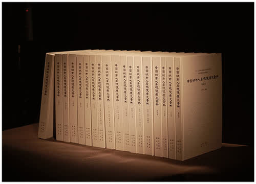
Figure 1. The atlas.
A professor and vice president of Xi’an University of Architecture and Technology, Wang serves as director of the Chinese Academy of Urban and Rural Construction and Cultural Heritage and as vice director of the Research Institute of New Urbanization and Human Settlement in Shaanxi Province. He has earned many honours for his work, including the Huaxia Construction Science and Technology Award, the Shaanxi Science and Technology Progress Award and China’s National Excellent Urban Planning Award. His 26 years in the field of urban planning and human settlements have given him the depth of experience to put together this remarkable series of books.
The great majority of the maps in the books date from the Qing Dynasty, mostly from the Kangxi to Guangxu periods (1654–1908) (see Figures 2 and 3). A few come from the Ming Dynasty (1368–1644), and the oldest one in the collection is the Lv Dafang Chang’an map from the third year of the Yuanfeng Period of the North Song Dynasty (1080). The most recent one was created in 1947, two years before the end of the Republic of China. Wang selected maps that best express the urban planning thoughts behind each city, so that readers can understand the character of each place.
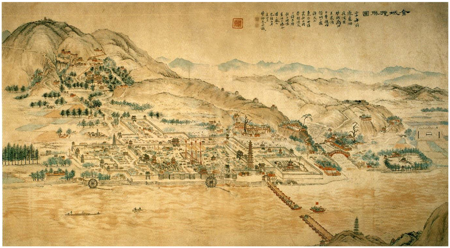
Figure 2. Map of Jincheng (Lanzhou) made during the reign of Emperor Guangxu of the Qing Dynasty, who ruled from 1875 to 1908.
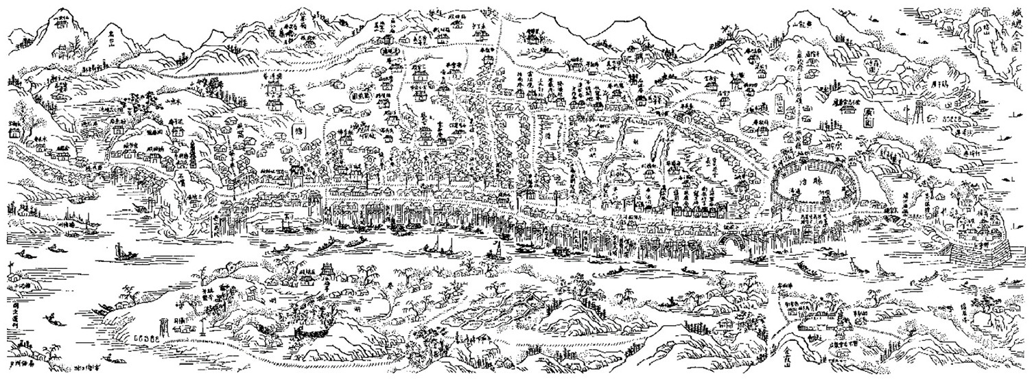
Figure 3. County General Map of the city of Xiangtan made in the 22nd year of the reign of the Jiaqing Emperor of the Qing Dynasty (1817).
Wang follows the traditional format of ‘maps on the left and record on the right’, combining drawings and text on each spread so that the two types of material support each other and add depth to our understanding. He and his team of researchers sorted through thousands of historical documents to capture in words the classical ideas and methods of planning that underpin the wonderful old maps in these books. The repetitive arrangement makes it easy for readers to dip in and out of each volume, browsing from town to town and then diving deeper whenever they find something particularly interesting. The variety of images used in the publication is impressive – from typical city maps and scale maps to sets of eight views of a particular town, a traditional way of capturing the beauty of important places.
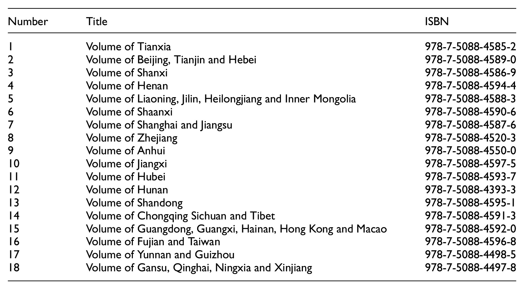
The books cover the entire country – all 23 provinces, five autonomous regions, four independent municipalities (Beijing, Chongqing, Shanghai and Tianjin) and two special administrative regions (Hong Kong and Macau). The first volume provides an overview of the typical Chinese planning structure – what is commonly referred to as the tianxia. It looks at the concepts shaping the capitals of ancient dynasties, as well as typical cities in the network of Five Great Mountains and Four Main Rivers (Yangtze, Yellow, Huai and Ji). It also examines the special urban patterns of towns near the Great Wall and Grand Canal.
The other 17 volumes focus on particular provinces or regions, letting us see the continuity and diversity of urban forms in China. We learn to appreciate the adaptability of certain ideas and the persistence of others. We begin to grasp the ongoing influence of both the universal and the local in the development of Chinese cities. The books examine the construction practices and data for each place, using this to identify the characteristics of local urban planning. Taken altogether, the multi-part publication serves as a database of historical Chinese urban planning.
Wang identifies 10 forces shaping Chinese urbanism: the spirit of the Chinese city; the connection between the urban and natural landscapes; humanistic space planning; urban heritage conservation; the balance between urban planning and economic factors; the construction of urban scenes; ecological issues; the contribution of government officials; the cooperation of the literati and local craftspeople; and the ongoing influence of Chinese virtues. Wang argues that these forces have shaped a humanistic approach to planning that solves functional issues, while contributing to a larger culture that ties people together. Perhaps this explains the powerful emotional connection that most Chinese feel towards their ancestral towns. We can see this in action each year when hundreds of millions of Chinese visit their family homes at the lunar new year.
Considered one volume at a time, Historical Maps and Classical Thoughts of Human Settlements in Chinese Cities offers wonderful insights into particular places in the country’s urban landscape. Taken as a whole, it serves as a remarkable resource that scholars, planners, architects and government officials will use for many decades. The scope and breadth of Wang’s research, as well as the depth of his analysis, make an invaluable contribution to the field of urban planning theory that will be appreciated by experts in both China and the rest of the world. Most important, this impressive publication underscores China’s rich tradition of making cities where people and nature, science and art are in balance.
Appendix
Related articles
If you enjoyed this review, the following articles published in Urban Studies might also be of interest:
|
The urbanisation of rural migrants and the making of urban villages in contemporary China Yang Zhan An ethnographic account of the spatial and social production of Chinese urban villages. |
Francesca Governa, Angelo Sampieri 'Promoting the Chinese urban dream': New towns in contemporary China as a key tool of national strategy. |
|
|
From an emerging market to a multifaceted urban society: Urban China studies Shenjing He, Junxi Qian A total of 24 articles published in Urban Studies have been selected to represent the scope of urban China studies in this journal Virtual Special Issue. |
Ancient and current resilience in the Chengdu Plain: Agropolitan development re-‘revisited’ Daniel B Abramson Abramson presents agropolitanism and resilience as a two-fold framework for interpreting the broad challenges and opportunities of urbanisation in China (and other populous, long-settled and highly food-productive regions) focusing on the Chengdu Plain. |
|
|
Non Arkaraprasertkul Should gentrification cease to automatically be understood as referring to a process with clear winners and losers? |
Junxi Qian, Xueqiong Tang This article contributes to the agendas of ordinary city and comparative urbanism by applying this epistemology to analyses of the recent urban development and urban strategies in Ruili, Yunnan, a small border city at China’s south-west frontier. |
Read more book reviews on the Urban Studies blog.

Comments
You need to be logged in to make a comment. Please Login or Register
There are no comments on this resource.